Planning application · ABS/APP/2026/1551
More time sought for approved anemometer mast up to 80 metres high.
Land On Fasque and Glendye Estate Fasque Plateau Strachan Banchory Aberdeenshire
Free with a City Scope account. One email, when the council decides.
Also email me new applications nearby · £1 a month for one alert. Cancel any time.
Preview alerts near your postcode
- New-Build & Major Development
- Small 4/10
- Met Mast
- Planning Permission Time Extension

Overview
Why it’s worth watching
Discharge of a healthcare obligation on a 120-home development has clear local infrastructure and housing consequences.
- Today
- An existing anemometer mast on land described as managed grouse moor.
- Proposed
- Continue siting the mast for a further four years.
- Size
- 80 metres maximum mast height · 0.10 ha site area
- Stage
- Past its target date of 11 Nov 2026.
The council writes only to properties within 20 metres of an application site. Who is told


In plain English
This application seeks to change the time condition on the already-approved anemometer mast scheme under reference APP/2024/0496. The form says the mast is already in place and seeks permission for its continued use for a further four years to monitor wind resource data before construction. The form also refers to permission APP/2018/1689.
Written with AI from the application form and the council record.
Keep reading
Official records · coverage in progress
1,742 of 1,898 official records received 1 Sept 2025 – 31 Aug 2026 were available when checked on 6 Sept 2026. 156 records from that period are still being added or checked.
Proposals and decisions come from Aberdeenshire Council. Additional summaries and analysis are being added where verified.
Check the council’s planning registerTrack this application
How do I track planning application ABS/APP/2026/1551?
Follow it on City Scope. This page is checked against the Aberdeenshire Council planning register and shows the latest status, decision and documents for ABS/APP/2026/1551. City Scope can email you when this application is decided, free with a City Scope account. To comment on the application, use the Aberdeenshire Council planning portal.
On the street
What neighbours would notice.
- 01
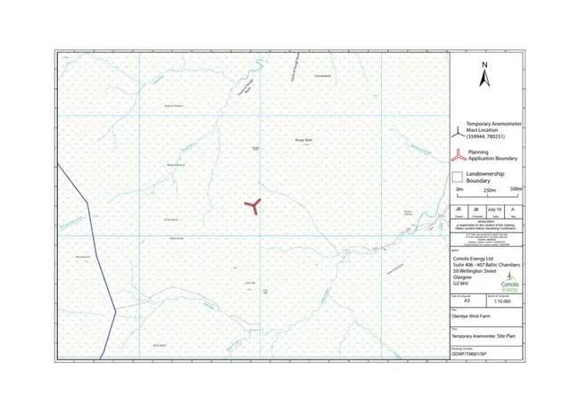
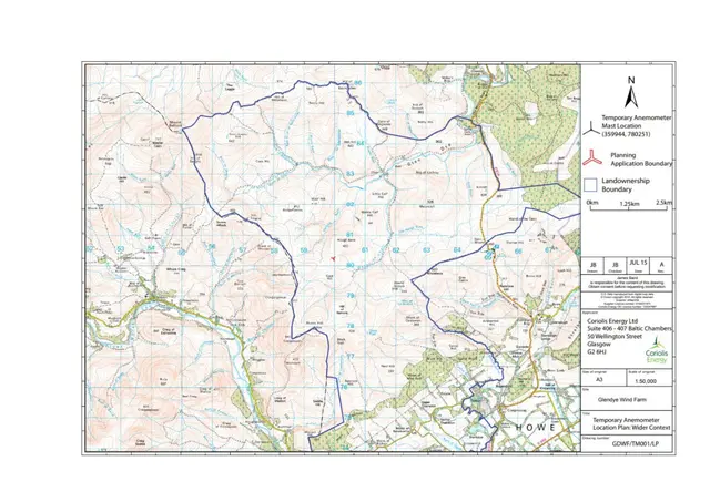
The application concerns continued siting of an existing anemometer mast, up to 80 metres high.
Questions
What is an anemometer mast for?
The form says it would be used to monitor wind resource data before construction.
Which earlier permissions are mentioned?
The description refers to APP/2024/0496. The form also refers to APP/2018/1689.
From the application form
The application form
Every answer the applicant gave on the council’s form, searchable.
Tags
- Met Mast
- Planning Permission Time Extension
What each tag is based on
- Met Mast
- “Erection of an Anemometer Mast”
- Planning Permission Time Extension
- “Without Compliance with Condition 1 (Time) of Planning Permission”
As lodged
The drawings.


All documents (4)
On the map
Open the planning map →© MapTiler / OpenFreeMap © OpenStreetMap contributors
Where it’s at
Comments have closed. The target date for a decision has passed.
- Received11 Sept 2026
- Validated11 Sept 2026The council has everything it needs.
- Comments closed2 Oct 2026Usual deadline. Late comments may still count.
- Target decision (next)11 Nov 20262-month target for local developments.
- DecisionNot yet
The record
- Reference
- ABS/APP/2026/1551
- Address
- Land On Fasque And Glendye Estate Fasque Plateau Strachan Banchory Aberdeenshire
- Status
- Awaiting decision
- Category
- New-Build & Major Development
- Impact scale
- 4/10
- Authority
- Aberdeenshire Council
- Received
- Validated
- Last checked
- Added to City Scope
Discussion
Talk about this application.
Share what you know about the site with other City Scope readers.