Burdiehouse Burn restoration proposed south of Lasswade Grove
Plans for land south of Lasswade Grove would reshape part of Burdiehouse Burn, reconnect its floodplain, move a path back from the water, replace a bridge and add amphitheatre-style seating on the north bank.
View the full application record
Open the live City Scope application page for documents, council links, tags, insights and status updates for reference 26/02211/FUL.
A stretch of Burdiehouse Burn Valley Park could be reshaped under plans for river restoration and public-realm works south of Lasswade Grove.
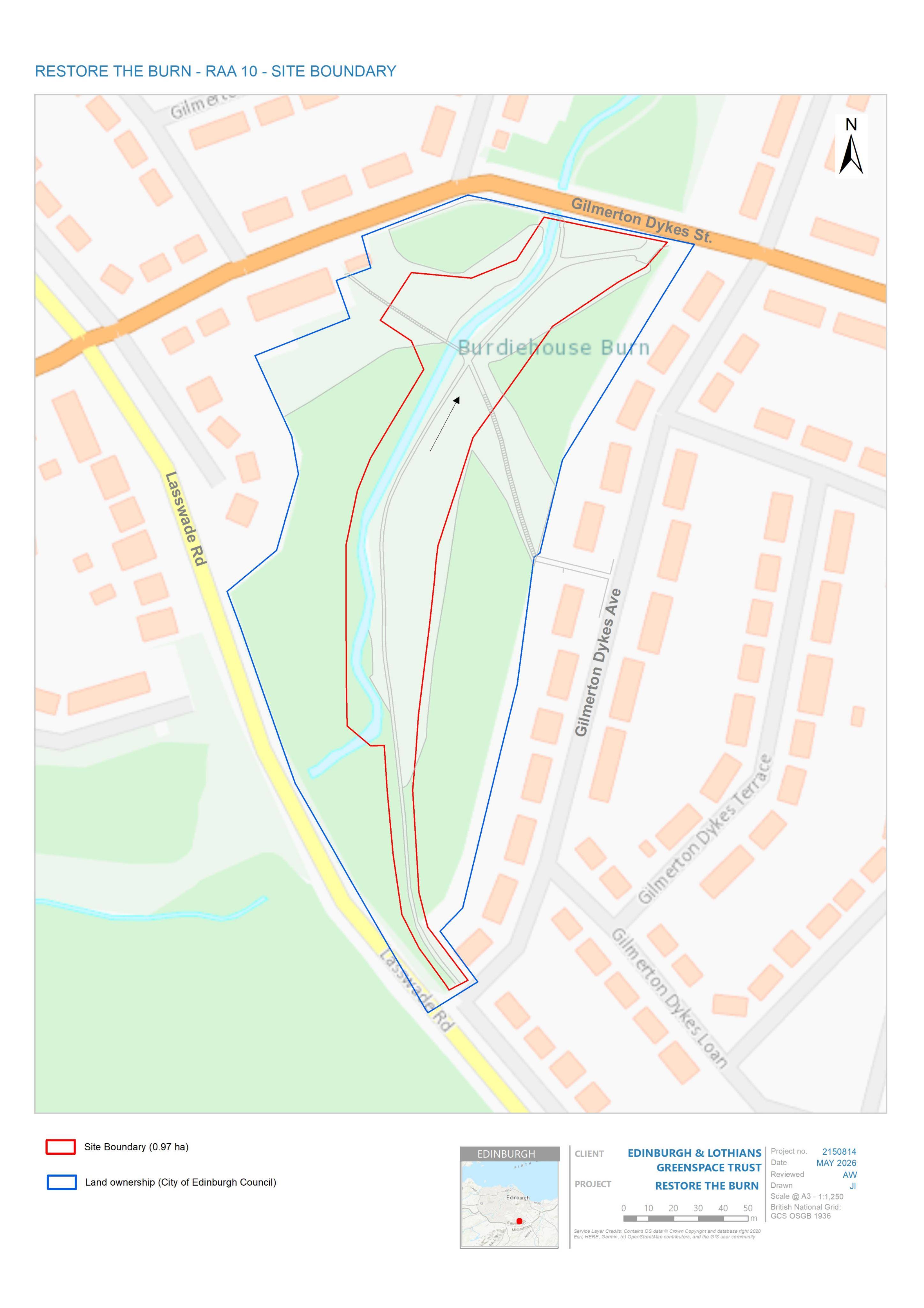
The proposal is for land about 130 metres south of 12 Lasswade Grove, in the Burdiehouse area of Edinburgh. It would alter the burn itself, change how the adjacent path sits beside the water, replace an existing bridge and add new seating on the north bank.
The application is notable because it is not a conventional building project. It is about changing the landscape of a public green corridor: the burn, its floodplain, nearby habitats, walking routes and places to sit.
What is proposed
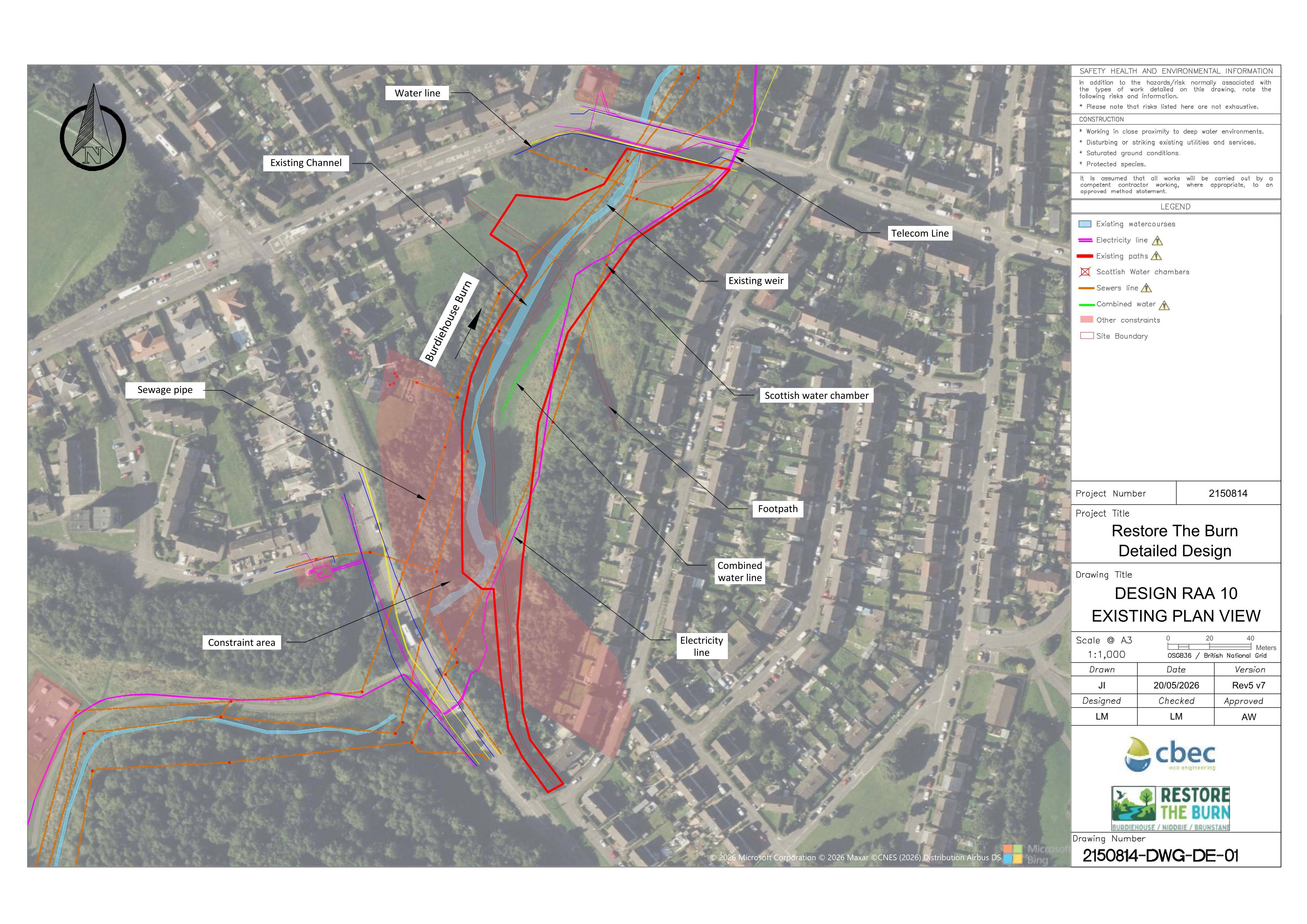
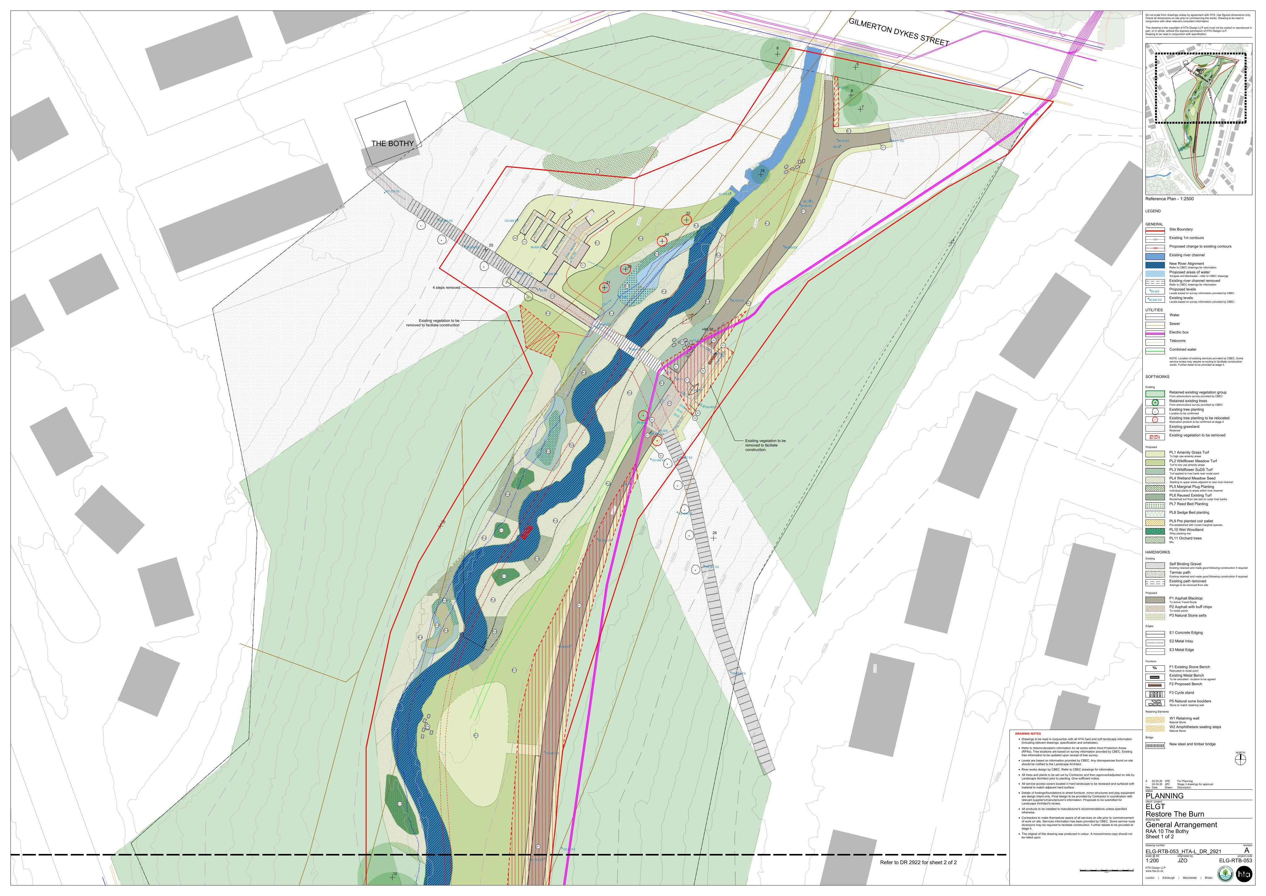
The core of the plan is river restoration. The burn would be re-meandered, meaning the channel would be given a more winding form rather than a straighter engineered alignment. The channel would also be reprofiled, and the floodplain would be reconnected.
In practical terms, that points to works intended to change how the watercourse sits in the valley floor and how surrounding land interacts with it during higher flows.
The surrounding landscape works include:
- re-meandering the burn channel;
- associated channel reprofiling;
- reconnection of the floodplain;
- diversification of existing habitats;
- setting the existing path further back from the burn;
- replacement of the existing bridge; and
- new amphitheatre seating on the north bank.
Together, those changes would affect both the ecology of the burn corridor and the everyday experience of people walking through this part of the park.
Where the site is
The site is recorded as land 130 metres south of 12 Lasswade Grove, Edinburgh. Its mapped position places it within the Burdiehouse Burn corridor in the south of the city.
Burdiehouse Burn Valley Park is an important local green route, with paths, open space and play facilities serving surrounding residential areas. The burn and its valley form a natural spine through the neighbourhood, so changes to the watercourse, bridge and path network are likely to be visible to regular park users.
The proposal also sits near another recent park-related planning matter: a separate application for a replacement concrete skatepark in the area known as the Dip within Burdiehouse Burn Valley Park, next to the existing play area and linking into the path network, was listed as granted under reference 26/00827/CLP. That is a separate case, but it underlines the level of current public-realm interest in this part of the park.
Why re-meandering matters
Urban burns have often been straightened, constrained or disconnected from their natural floodplain over time. Re-meandering is a common river restoration approach that seeks to give a watercourse a more natural shape and improve the relationship between the channel, banks and surrounding land.
For residents, the most noticeable changes may not be technical. They could include a burn that looks less engineered, a path set further away from the water’s edge, a new bridge in place of the existing one, and seating designed to create a small gathering or viewing area on the north bank.
The habitat diversification element is also significant. Changes to banks, wet areas, planting and grassland can alter the value of a corridor for wildlife, while also changing how open or enclosed a park feels.
Path, bridge and seating changes
The plan would set the existing path back from the burn. That could change how people move through this section of the valley, especially where the path currently runs close to the watercourse.
A replacement bridge is also proposed. The application description does not set out the design of the new bridge, but a bridge replacement can be one of the most visible parts of a river or park project because it affects both access and views along the burn.
The proposed amphitheatre seating on the north bank is another public-facing element. Amphitheatre-style seating normally suggests stepped or terraced seating built into a slope or bank, providing a place to sit, gather or look across the restored landscape. The planning description does not name a specific event use, so the clearest reading is that it would add a new informal seating feature within the park landscape.
Why this application is worth watching
This is a modest-scale planning application in built-form terms, but it could have a bigger effect on how a well-used green corridor functions.
For neighbours and park users, the main issues to follow are likely to be:
- how much of the burn channel would be altered;
- where the path would be moved;
- what the replacement bridge would look like;
- how the north-bank seating would fit into the landscape;
- how habitat changes would be managed; and
- how construction works would affect access through the park.
For planners and environmental campaigners, the floodplain reconnection and channel reprofiling are the most important technical components. For local residents, the path, bridge and seating may be the most immediate changes on the ground.
What happens next
The application has been validated by the City of Edinburgh Council and is currently marked as awaiting assessment. A decision has not yet been recorded.
Residents can search for the case on the council’s planning portal using reference 26/02211/FUL. The address to search is Land 130 Metres South Of 12 Lasswade Grove Edinburgh.
Building City Scope — tools to make Edinburgh's planning data easier to search, understand and use.